Pakistan’s EO-3 Disinformation Included an AI-Generated Port That Does Not Exist
Fabricated Gwadar Imagery Highlights Strategic Narrative Targeting Around CPEC Hub
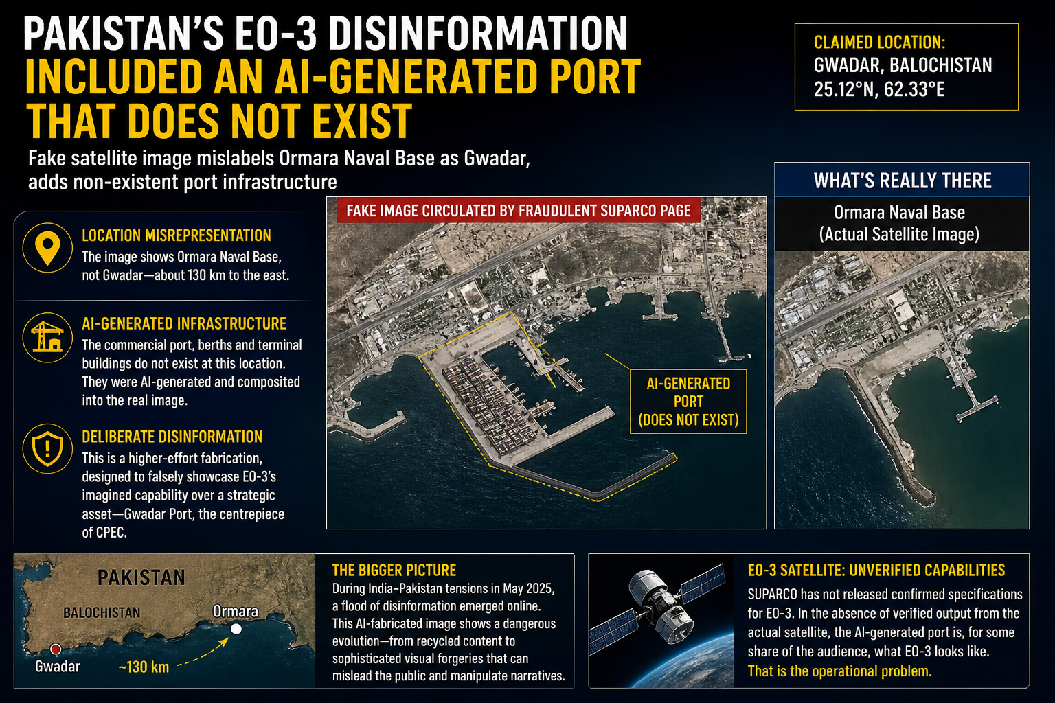
Of the three fabricated satellite images that circulated through a fraudulent SUPARCO Facebook page following EO-3’s launch in late April, one stands apart in the effort required to produce it. All three were caught, and caught quickly. The distinction lies in what is the most elaborate required. Someone did not simply find an old photograph and relabel it. They constructed an infrastructure that does not physically exist and composited it into a real satellite photograph of a Pakistani military installation.
The image was posted with coordinates identifying the location as Gwadar, Balochistan, at 25.12°N, 62.33°E. It appeared to show a functioning commercial shipping port: vessel berths, terminal buildings, operational access channels — the kind of image that would confirm EO-3’s capability to capture economically significant civilian infrastructure along Pakistan’s southern coastline.
Independent open-source analysts identified two separate problems. The first was location misrepresentation.
The underlying photograph did not show Gwadar. It showed the Ormara Naval Base — a Pakistan Navy installation approximately 130 kilometres east along the Balochistan coast. Gwadar is Pakistan’s flagship commercial port and the centrepiece of the China-Pakistan Economic Corridor. Substituting one for the other was either a geographical error or a deliberate choice. Given the level of manipulation present elsewhere in the image, the latter seems more plausible.
The second problem was structural. The shipping terminal visible in the image — the facility that made it read as commercial port activity — does not exist at that location. Analysts who cross-referenced the photograph against verified satellite and mapping data of the Ormara coastline found no corresponding infrastructure. The terminal appears to have been AI-generated and composited into the base photograph, replacing visual markers of a naval installation with something that read as civilian and commercially active.
This represents a meaningful escalation in technique.
Recycling archived photographs and relabelling them is a low-effort operation, requiring little beyond access to existing imagery and the willingness to apply false metadata. The Karachi Port image in the same batch — traced to SUPARCO’s own website with a 2024 timestamp — falls into that category. So does the Faisal Mosque image, matched against publicly available mapping data with identical vehicle and shadow positions. Those fabrications were consequential. The production effort required to create them was not.
Generating AI infrastructure and compositing it into a real aerial photograph of a military base is a different order of work. It requires either purpose-built image generation capability applied to this specific task or substantial digital manipulation skill. The result passed without triggering immediate scepticism among general audiences. The anomaly was visible to trained analysts comparing the image against verified geographic data. For everyone else encountering a post attributed to Pakistan’s national space agency, it was largely invisible.
The choice of Gwadar as the stated location is worth examining. The port carries significant geopolitical weight as the centrepiece of CPEC, and has been the subject of sustained international attention, Chinese investment controversies, infrastructure disputes, and security concerns tied to Balochistan.
An image claiming to show high-resolution EO-3 imagery of Gwadar’s port infrastructure carries a specific strategic valence that an image of an unremarkable inland location does not. Whether the choice was motivated by that significance, or simply by the availability of the Ormara base photograph as a base layer, cannot be determined from the available evidence.
A brief armed conflict between India and Pakistan broke out in May 2025, after India launched missile strikes codenamed Operation Sindoor in response to the Pahalgam terrorist attack on 22 April 2025, in which 26 civilians were killed. During that conflict, a surge of disinformation proliferated online from multiple directions.
Pakistani-origin fabrications included footage from unrelated conflicts and old photographs recaptioned as evidence of Indian losses. In one documented case, footage circulated as evidence of destroyed Indian military infrastructure was traced to an army simulation video game — gameplay recordings repurposed as real-world evidence.
India’s Press Information Bureau, a government body, claimed to have countered several instances of disinformation, though independent analysts documented fabricated content circulating on both sides. Speed was the apparent priority in that campaign: distribute the image quickly, shape the early narrative, and let distribution outrun verification.
The EO-3 fake imagery suggests a different approach. The construction is more deliberate, the compositing careful, the geographic specificity precise. It was still caught quickly. The production investment, though, is not consistent with casual or opportunistic disinformation. Analysts have suggested it is consistent with an attempt to demonstrate a capability — satellite imagery of strategically sensitive Pakistani infrastructure — that EO-3 may or may not actually possess. That attribution remains unverified.
SUPARCO has not released confirmed specifications for EO-3, and its precise imaging resolution and capabilities remain publicly unconfirmed. The agency had not, at the time of publication, addressed the fake page or the fabrications it circulated. The Gwadar port in the image does not exist in reality. The satellite exists in orbit. In the absence of verified output from the actual satellite, the AI-generated port is, for some share of the audience, what EO-3 looks like. That is the operational problem.